July 10, 1980
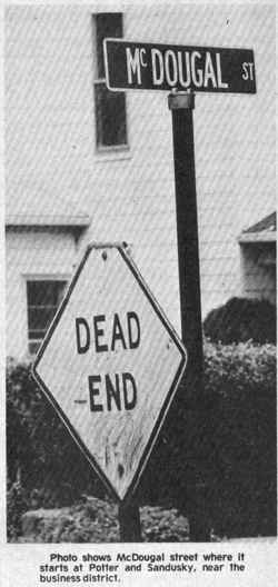
Picture #1 – Photo shows McDougal street where it starts at Potter and Sandusky, near the business district.
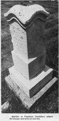
Picture #2 – Marker in Fountain Cemetery where McDougal and wife are buried.
As a boy I lived at the corner of McDougal and Cadwallader and in my later years have often wondered how the street got its name.
Many streets in Fostoria are named after prominent resident but, in my research for many articles, I never found data showing who McDougal street was named after.
During a recent session at the library, I was talking to Willis Wyant, an active member of The Fostoria Area Historical Society and he told me how McDougal street got its name.
The street was named after Benjamin “Barney” McDougal…also spelled McDougle at various placed in the old records.
Most readers will recognize the name as Scotch. McDougal’s ancestors emigrated to America from Edinburgh when people from all over Europe began arriving in America.
A VIRGINIAN
The old Seneca County History says McDougal was born April 3, 1795 in Culpeper County, VA. He moved to Perry County, Ohio in 1832 and settled in Seneca County in 1834.
In addition to farming the land he acquired in Seneca County, he was also known as a Fence Viewer…one who inspected property line fences on newly surveyed land.
The street which was eventually named after him continued past the town’s limits and was a rural road that passed his farm property.
The old Seneca County maps show the land he owned, and have his name B. McDougal inscribed on them. His property consisted of the following parcels of land:
PARCEL 1
In 1832 he acquired from the U.S. Government, the southeast quarter of the southeast quarter of section four in Township Two north of Range 13, containing 40 acres. This parcel was later sold by the McDougal heirs and in 1912 was acquired by Andrew U. Fraver, father of Ivan Fraver who still farms the land.
PARCEL 2
In 1835 McDougal acquired the southwest quarter of the northeast quarter of Section three in Township Two north of Range 13, containing 39.27 acres.
PARCEL 3
In 1836 McDougal acquired the southeast quarter of the northwest quarter of section three in Township two north of Range 13, containing 39.35 acres.
In 1865 Barbara Rinebold acquired 3, and 24 acres of parcel and Abraham Rinebold acquired all the land in parcel 2, plus the portion of parcel 3 which was not sold to Barbara Rinebold.
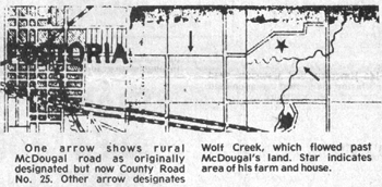
Wolf Creek flowed not far from McDougal’s land. That was back in the days when wolves roamed all of that area, and that is how the creek got its name.
DIED AT AGE 48
McDougal died July 15, 1843, nine years after settling in Seneca County. His wife Nancy (Updyke) continued to live in the house which was originally built on their land until her death March 18, 1872. No one living today seems to know exactly where the McDougal house and other buildings were located, or if they still exist.
Since McDougal died before Cemetery Fountain was formed, he must have been buried on Cemetery Hill, where Fostoria City Hospital is not. That cemetery was used by Risdon and Rome until the new cemetery was ready. McDougal must have been first buried on “the hill” and later moved to Fountain Cemetery and laid beside his wife. The old grave marker, shown in the accompanying photo, is almost beyond deciphering. The site is section A-lot 12. Adjacent to the McDougal marker is a more imposing one where his daughter Ruth and her husband Philip Byers are buried.
MCDOUGAL’S HEIRS
McDougal’s daughter Lucy A. married Jeremiah Pankhurst, and the couple had 13 children. The Pankhurst family was well known in the rural area east of Fostoria, they too being farmers. A rural schoolhouse was named after that family, quite understandably, with 13 children filling the school seats.
Other heirs of Benjamin McDougal were: Charity Jane, who married Arthur N. Wyant; Sarah who married Thornton Lomor; James W. who moved to Germaine, Iowa. Arthur Wyant was the grandfather of Willis Wyant who told me how the street git its name.
MCDOUGAL STREET THEN
McDougal Street may not have been one of Fostoria’s most prestigious, but, many years ago it was made up of medium income families and houses. It holds many memories for me, having spent 15 or more years on that street, and more in that area.
I watched Charles “Gene” Wilson lay bricks when the street was paved. Prior to that, we kids waded in knee-deep water after summer rain storms.
I watched roofers install slate on the four Cadwallader houses on that street just west of Cadwallader Street, and it still looks good after more than 65 years.
Small maple trees our family planted on Cadwallader boulevard where we lived are still there.
The old train watering tower is gone. The T&OC Depot an important one back then, no longer dispatches trains, but is used by Gray Printing Co. as a warehouse.
I REMEMBER
Some of the names I still recall as living on McDougal street back then are: Miss Mason, my first grade teacher at Whittier; Mr. McClellan, father of Claudia Hillier; the Wolf family…he had a second-hand store on S. Main; Avis Parsell, plumber; Henry Peter, who had a restaurant where the Review Times is now; Dicken, the tinshop man; the Eger family; E.R. Kellogg of J.C. Penney Co., and son Wilbur, one of my best friends; Emma Reber and her parents…Emma worked at The Review with longest continuous employment; John Dell family…Joe and Ray still run the family restaurant; Frank Babcock, barber; Vic Schuh, a printer at The Review and sports wirter; Roy Hartsook, a printer with The Times; Pius Bloom; the Lorah family, the Harriman family; Jess Earl family and many others.
Houses on some parts of McDougal street have been maintained and look like they did years ago; others have been left to deteriorate to some extent.
The accompanying illustrations provide proof that there was a Benjamin “Barney” McDougal and that he lived in Seneca County…that there is a McDougal street…and he is buried in Fountain Cemetery.
Too bad there isn’t a photo around to let readers know what the old Scotchman looked like.
NOTE: The accompanying map is not the original one showing McDougal’s land holdings and residence. It was not reproducible. The map used is one of later date, marked accurately to provide descriptive information.